Distance: 7.8 miles
Hikers: Vance and Quinn
4000 footer completion count: Mount Cabot #31 (4,170 feet)
As we made our way west on 302, the rain was heavy. All signs pointed toward a poncho clad hike. Interestingly, we neither arrived at our our intended destination nor required any rain gear. When we left for Cabot in the morning, I hastily instructed Google's GPS map service to take us to "Mount Cabot New Hampshire". The high-level view of the route looked appropriate so we obliviously just cruised along. When we reached our destination, it was clear that we were somewhere other than where we had intended to be. After a bit of research, it was clear we were at the Mt. Cabot trail trailhead. Unfortunately, this trail is no longer maintained because of a land dispute.
Google indicated that it would be more than an hour to travel by car to the other side of the mountain to hike the Bunnell Notch trail. We had already been driving for quite some time so we decided to see if hiking the Mt. Cabot trail would be possible. I called the WMNF but was unable to get through to anybody. Shortly thereafter, we ran into a couple that was relying on data from an old AMC book and map and was surprised to hear about the land dispute and the status of the trail. After discussing the situation with the other hikers and one of the neighbors, we decided to change our plans and hike the Mt. Cabot trail. Thus, our hike became an out-and-back on the Mt. Cabot trail (which combines with the Kilkenny Ridge trail for a mile and a half or so to the summit). I don't know the current status or details of the land dispute but if you're reading this post and are considering hiking Cabot, please hike the undisputed, established and maintained trails.
After sorting our situation out, we hit the trail! The lower section of the hike was quite muddy in spots and the grass was very high along the trail. It's clear that this trail hasn't been maintained in a while and that it doesn't get a high volume of foot traffic.

Quinn is always on the lookout for creatures. Below you'll find a picture of his latest find, his pal Slugworth:

If you click on the picture below, you'll see one of the fresh moose prints Quinn was following. One of the hikers we ran into had just passed a mother and her calf on the trail.

Crossing Bunnell Brook.

Hiking along the "ghost trail," Quinn finds an old sign.

The mist and fog hung low in the trees as we hiked along.

After slogging through some overgrown sections of trail, we reached the intersection of the Mt. Cabot/Kilkenny Ridge trail. The trail was rocky but well cared for from here on up.

It's always a pleasure and an adventure hiking with my buddy Quinn!

Here's Quinn on Bunnell Rock pondering what the views might look like on a sunny day.

Quinn seen ahead on the trail through a quiet, foggy forest.

Almost there!

We reached Cabot Cabin and decided to head in and leave a note to other hikers in the log book.

We worked up a good appetite on the hike and sat and enjoyed some sandwiches at the summit.

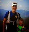
We didn't run into too many hikers on Cabot but fortunately, the couple that hiked the Mt. Cabot trail too arrived at the summit and took a picture for us.

We decided to stop back in the cabin so Quinn could try out the sleeping arrangements!

Exploring the roots!

The lush greenery toward the end of the hike was spectacular so we pulled over for another picture.

The rain held back and it was certainly interesting trekking along the ghost trail that's been removed from modern maps. Despite having to alter our plans, we had a really special day. Next time, I'll be much more intentional in the way I request directions! Until then, happy trails!
Quinn's Take
We completed our next hike, Mount Cabot. The trail started off flat, it was kind of like a road that was once used but was now over grown. We caught up with some nice people who had an older map that had the trail that we were hiking on. We found out that the trail has not been maintained since 2000. We continued hiking and we got to a clearing with a hill and there were some stream crossings. I spotted moose tracks in the mud and we stopped to take a picture of them. Once we got a little way farther up, it got foggy and we saw a sign that said "this trail is no longer maintained." It felt like a ghost trail! There was a cabin close to the peak where we took a break and wrote in the notebook that was there. Here we met a man who had just seen a moose and her calf. Must have been the same one whose tracks we saw!! The peak was cold and cloudy without any views because of the fog. The hike down was easy. At the base we saw a really cool flower. We weren't sure what kind it was, but maybe my grandmother does! Happy trails!
No comments:
Post a Comment